
Soubor:Qinghai Cross Section.jpg

Velikost tohoto náhledu: 340 × 599 pixelů. Jiná rozlišení: 136 × 240 pixelů | 272 × 480 pixelů | 436 × 768 pixelů | 581 × 1 024 pixelů | 1 163 × 2 048 pixelů | 3 672 × 6 467 pixelů.
Původní soubor (3 672 × 6 467 pixelů, velikost souboru: 4,62 MB, MIME typ: image/jpeg)
| Tento soubor pochází z Wikimedia Commons. Níže jsou zobrazeny informace, které obsahuje jeho tamější stránka s popisem souboru. |
Popis
| Popis | |
| Datum | |
| Zdroj | NASA Earth Observatory |
| Autor | Jesse Allen and Robert Simmon |
| Pozice fotografa | | Tento snímek a mnohé další na: OpenStreetMap |
|---|
Image captured by the Advanced Land Imager (ALI) on NASA’s Earth Observing-1 (EO-1) satellite. EO-1 ALI data provided courtesy of the NASA EO-1 team.
Licence
| This file is in the public domain in the United States because it was solely created by NASA. NASA copyright policy states that "NASA material is not protected by copyright unless noted". (See Template:PD-USGov, NASA copyright policy page or JPL Image Use Policy.) | ||
 |
Warnings:
|
Historie souboru
Kliknutím na datum a čas se zobrazí tehdejší verze souboru.
| Datum a čas | Náhled | Rozměry | Uživatel | Komentář | |
|---|---|---|---|---|---|
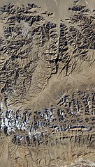
| současná | 27. 6. 2011, 15:04 | | 3 672 × 6 467 (4,62 MB) | Originalwana | {{Information |Description ={{en|1=The northernmost part of the scene shows flat land, while to the south lies a tapestry of mountains and valleys, with some peaks capped with snow and ice.}} |Source =[http://earthobservatory.nasa.gov/I |
Využití souboru
Tento soubor používá následující stránka:
Globální využití souboru
Tento soubor využívají následující wiki:
- Využití na ar.wikipedia.org
- Využití na ast.wikipedia.org
- Využití na ba.wikipedia.org
- Využití na be.wikipedia.org
- Využití na ca.wikipedia.org
- Využití na ce.wikipedia.org
- Využití na cy.wikipedia.org
- Využití na de.wikivoyage.org
- Využití na es.wikipedia.org
- Využití na eu.wikipedia.org
- Využití na fi.wikipedia.org
- Využití na fr.wikivoyage.org
- Využití na ga.wikipedia.org
- Využití na gl.wikipedia.org
- Využití na hr.wikipedia.org
- Využití na hy.wikipedia.org
- Využití na ia.wikipedia.org
- Využití na ka.wikipedia.org
- Využití na ku.wikipedia.org
- Využití na lmo.wikipedia.org
- Využití na mzn.wikipedia.org
- Využití na nn.wikipedia.org
- Využití na no.wikipedia.org
- Využití na os.wikipedia.org
- Využití na pl.wikipedia.org
- Využití na ro.wikipedia.org
- Využití na ru.wikipedia.org
- Využití na ru.wikinews.org
- Využití na sh.wikipedia.org
- Využití na sr.wikipedia.org
- Využití na tg.wikipedia.org
- Využití na tl.wikipedia.org
- Využití na tt.wikipedia.org
- Využití na vec.wikipedia.org
- Využití na vi.wikipedia.org
- Využití na www.wikidata.org