
Soubor:Oenosatellite.png
Větší rozlišení není k dispozici
Oenosatellite.png (530 × 532 pixelů, velikost souboru: 298 KB, MIME typ: image/png)
| Tento soubor pochází z Wikimedia Commons. Níže jsou zobrazeny informace, které obsahuje jeho tamější stránka s popisem souboru. |
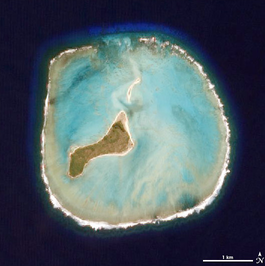
Popis
| Popis |
Deutsch: NASA-Satellitenbild des Oeno-Atolls (Pitcairninseln) im Pazifischen Ozean
English: NASA satellite picture of Oeno Atoll (Pitcairn Islands) in the Pacific Ocean
Taken by the Advanced Land Imager on NASA’s EO-1 satellite as part of a Mid-decadal Global Land Survey. |
| Datum | |
| Zdroj | http://earthobservatory.nasa.gov/Newsroom/NewImages/images.php3?img_id=17349 |
| Autor | NASA |
Licence
| This file is in the public domain in the United States because it was solely created by NASA. NASA copyright policy states that "NASA material is not protected by copyright unless noted". (See Template:PD-USGov, NASA copyright policy page or JPL Image Use Policy.) | ||
 |
Warnings:
|
Původní historie souboru
Original Uploader was Ryanjo (talk) at 3 August 2006.
| Poznámky | K tomuto souboru existují poznámky: Prohlédnout si poznámky na Commons |
Historie souboru
Kliknutím na datum a čas se zobrazí tehdejší verze souboru.
| Datum a čas | Náhled | Rozměry | Uživatel | Komentář | |
|---|---|---|---|---|---|
| současná | 29. 11. 2007, 09:11 | | 530 × 532 (298 KB) | Telim tor | == Information == {{Information |Description= {{de|NASA-Satellitenbild des Oeno-Atolls im Pazifischen Ozean}} {{en|NASA Satellite Image of Oeno Atoll in the Pacific Ocean}} Taken by the Advanced Land Imager on NASA’s EO-1 satellite as part of a Mid-deca |
Využití souboru
Tento soubor používají následující 2 stránky:
Globální využití souboru
Tento soubor využívají následující wiki:
- Využití na be.wikipedia.org
- Využití na ca.wikipedia.org
- Využití na ceb.wikipedia.org
- Využití na da.wikipedia.org
- Využití na en.wikipedia.org
- Využití na eo.wikipedia.org
- Využití na es.wikipedia.org
- Využití na fa.wikipedia.org
- Využití na frr.wikipedia.org
- Využití na hr.wikipedia.org
- Využití na id.wikipedia.org
- Využití na it.wikipedia.org
- Využití na la.wikipedia.org
- Využití na lt.wikipedia.org
- Využití na mrj.wikipedia.org
- Využití na my.wikipedia.org
- Využití na nl.wikipedia.org
- Využití na pih.wikipedia.org
- Využití na pl.wikipedia.org
- Využití na pt.wikipedia.org
- Využití na ru.wikipedia.org
- Využití na sk.wikipedia.org
- Využití na uk.wikipedia.org
- Využití na vi.wikipedia.org
- Využití na www.wikidata.org
- Využití na zh.wikipedia.org