
Soubor:Link light rail geographic map.svg

Velikost tohoto PNG náhledu tohoto SVG souboru: 550 × 600 pixelů. Jiná rozlišení: 220 × 240 pixelů | 440 × 480 pixelů | 705 × 768 pixelů | 939 × 1 024 pixelů | 1 879 × 2 048 pixelů | 1 600 × 1 744 pixelů.
Původní soubor (soubor SVG, nominální rozměr: 1 600 × 1 744 pixelů, velikost souboru: 597 KB)
| Tento soubor pochází z Wikimedia Commons. Níže jsou zobrazeny informace, které obsahuje jeho tamější stránka s popisem souboru. |
Popis

|
U tohoto obrázku se očekává, že bude vždy aktuální. Neváhejte jej aktualizovat v případě potřeby.
|
| Popis |
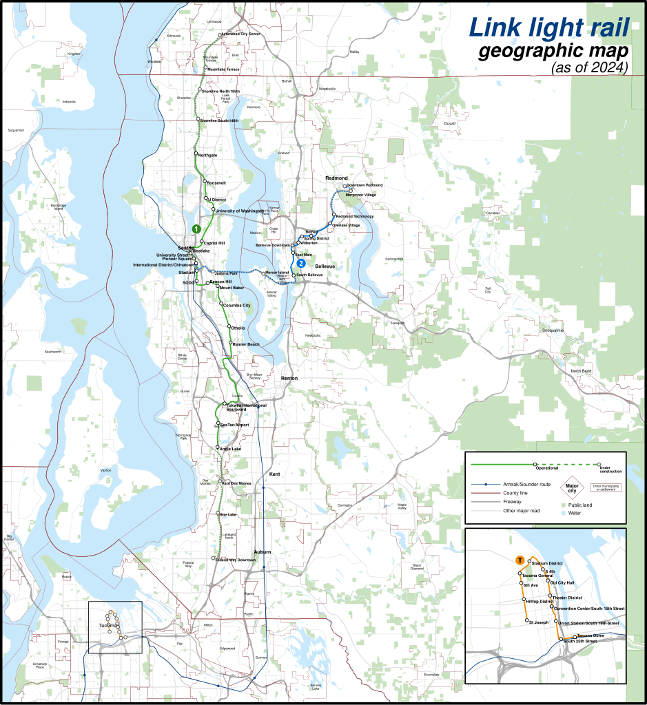
English: A geographically-accurate map of lines of the Link light rail, including parts under construction (dashed in map), overlayed on a basemap containing the Silver Line and commuter rail lines, municipalities, roads, water areas, area landmarks, and green spaces. Shapefiles from the United States Census Bureau, the U.S. Geological Survey (USGS) Gap Analysis Project (GAP), Sound Transit, and OpenStreetMap (© OpenStreetMap contributors), converted with Mapshaper and Inkscape (Mercator projection). |
| Datum | |
| Zdroj | Vlastní dílo |
| Autor | Twotwofourtysix |
Licence
Já, držitel autorských práv k tomuto dílu, ho tímto zveřejňuji za podmínek následující licence:
Tento soubor podléhá licenci Creative Commons Uveďte autora-Zachovejte licenci 4.0 International
- Dílo smíte:
- šířit – kopírovat, distribuovat a sdělovat veřejnosti
- upravovat – pozměňovat, doplňovat, využívat celé nebo částečně v jiných dílech
- Za těchto podmínek:
- uveďte autora – Máte povinnost uvést autorství, poskytnout odkaz na licenci a uvést, pokud jste provedli změny. Toho můžete docílit jakýmkoli rozumným způsobem, avšak ne způsobem naznačujícím, že by poskytovatel licence schvaloval nebo podporoval vás nebo vaše užití díla.
- zachovejte licenci – Pokud tento materiál jakkoliv upravíte, přepracujete nebo použijete ve svém díle, musíte své příspěvky šířit pod stejnou nebo slučitelnou licencí jako originál.
Historie souboru
Kliknutím na datum a čas se zobrazí tehdejší verze souboru.
| Datum a čas | Náhled | Rozměry | Uživatel | Komentář | |
|---|---|---|---|---|---|
| současná | 5. 5. 2024, 04:49 | | 1 600 × 1 744 (597 KB) | Twotwofourtysix | Update with opening of line section |
| 4. 5. 2024, 09:58 |  | 1 600 × 1 744 (635 KB) | OrdinaryScarlett | Update date | |
| 4. 5. 2024, 09:01 |  | 1 600 × 1 744 (673 KB) | SounderBruce | Remove CDP "boundaries" that change with every census; cleanup label placement on 2 Line | |
| 1. 5. 2024, 04:41 |  | 1 600 × 1 744 (651 KB) | OrdinaryScarlett | Update 2 Line and Lynnwood and Federal Way Link Extension station names | |
| 19. 1. 2024, 22:05 |  | 1 600 × 1 744 (690 KB) | SounderBruce | Removing most labels for CDPs, which are arbitrarily assigned by the Census Bureau and change frequently; boundaries should also be deleted at some point | |
| 19. 1. 2024, 16:18 |  | 1 600 × 1 744 (650 KB) | Twotwofourtysix | Adds legend & title, adjusts colours | |
| 18. 1. 2024, 17:58 |  | 1 600 × 1 744 (1,76 MB) | Twotwofourtysix | Uploaded own work with UploadWizard |
Využití souboru
Tento soubor používá následující stránka:
Globální využití souboru
Tento soubor využívají následující wiki:
- Využití na ca.wikipedia.org
- Využití na de.wikipedia.org
- Využití na de.wikivoyage.org
- Využití na en.wikipedia.org
- Využití na es.wikipedia.org
- Využití na fa.wikipedia.org
- Využití na fr.wikipedia.org
- Využití na it.wikipedia.org
- Využití na mr.wikipedia.org
- Využití na uk.wikipedia.org
- Využití na www.wikidata.org
- Využití na zh.wikipedia.org