
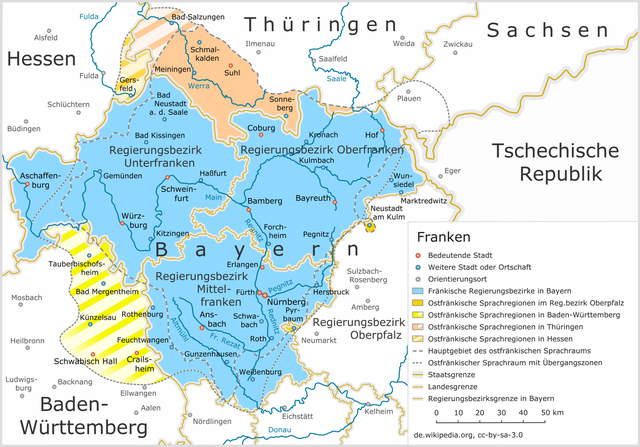
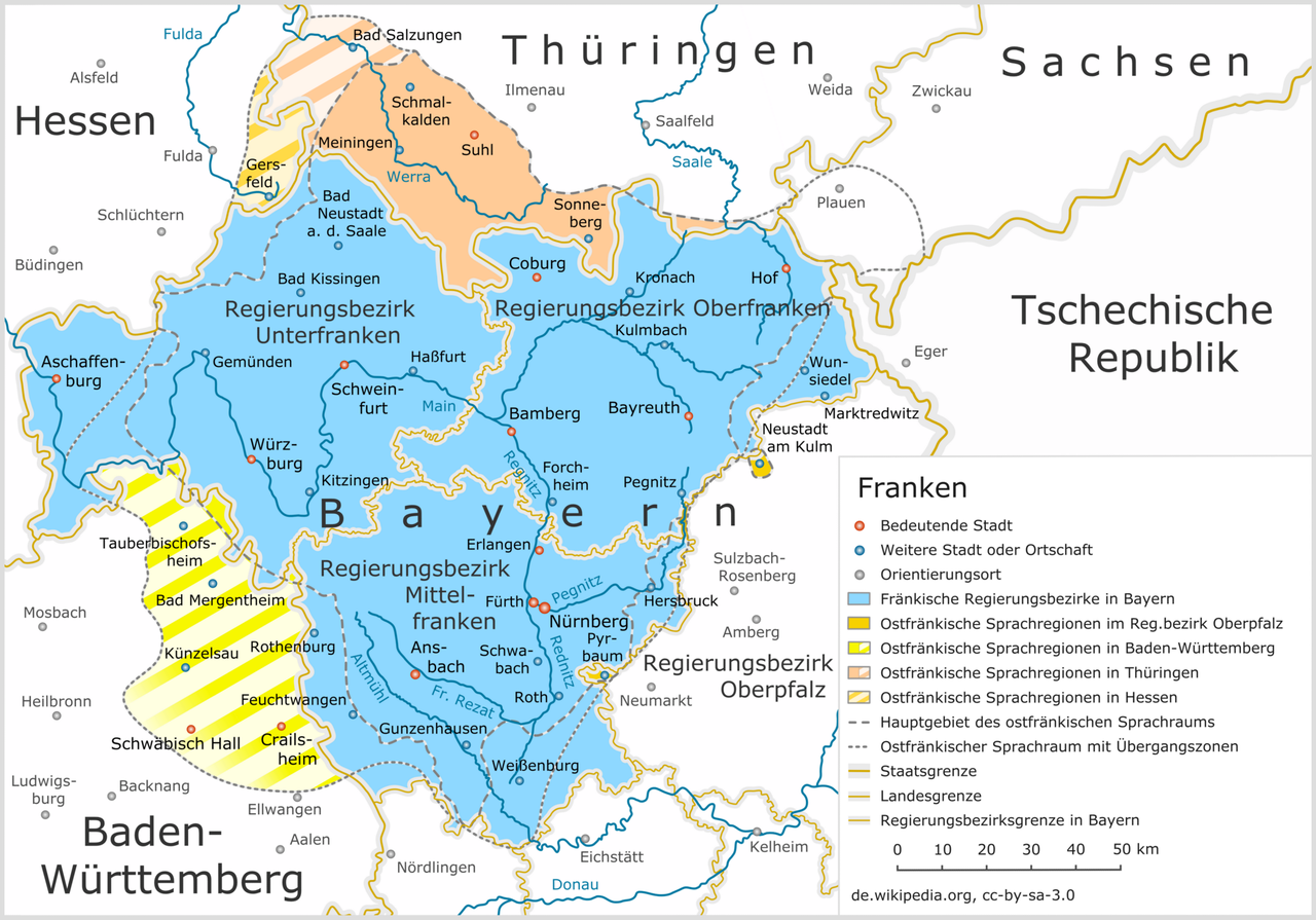
Soubor:Franken Region Uebersicht.png

Velikost tohoto náhledu: 800 × 559 pixelů. Jiná rozlišení: 320 × 224 pixelů | 640 × 447 pixelů | 1 024 × 716 pixelů | 1 280 × 895 pixelů | 2 360 × 1 650 pixelů.
Původní soubor (2 360 × 1 650 pixelů, velikost souboru: 1,68 MB, MIME typ: image/png)
| Tento soubor pochází z Wikimedia Commons. Níže jsou zobrazeny informace, které obsahuje jeho tamější stránka s popisem souboru. |
Popis
| Popis |
Deutsch: Franken
English: Franconia
Français : Franconie |
| Datum | |
| Zdroj | Vlastní dílo |
| Autor | Mikmaq |
| Svolení (Užití tohoto souboru) |
cc-by-sa-3.0 |
| Další verze |
 Aragonese version  Catalonian version  Dutch version  English version  French version  Italian version  Portuguese version  Spanish version  Upper Sorbian version |
Licence
Já, držitel autorských práv k tomuto dílu, ho tímto zveřejňuji za podmínek následující licence:
Tento soubor podléhá licenci Creative Commons Uveďte autora-Zachovejte licenci 3.0 Unported
- Dílo smíte:
- šířit – kopírovat, distribuovat a sdělovat veřejnosti
- upravovat – pozměňovat, doplňovat, využívat celé nebo částečně v jiných dílech
- Za těchto podmínek:
- uveďte autora – Máte povinnost uvést autorství, poskytnout odkaz na licenci a uvést, pokud jste provedli změny. Toho můžete docílit jakýmkoli rozumným způsobem, avšak ne způsobem naznačujícím, že by poskytovatel licence schvaloval nebo podporoval vás nebo vaše užití díla.
- zachovejte licenci – Pokud tento materiál jakkoliv upravíte, přepracujete nebo použijete ve svém díle, musíte své příspěvky šířit pod stejnou nebo slučitelnou licencí jako originál.
Historie souboru
Kliknutím na datum a čas se zobrazí tehdejší verze souboru.
| Datum a čas | Náhled | Rozměry | Uživatel | Komentář | |
|---|---|---|---|---|---|
| současná | 28. 7. 2018, 00:30 | | 2 360 × 1 650 (1,68 MB) | Mikmaq | version 1.7 |
| 15. 7. 2018, 20:49 |  | 2 360 × 1 650 (1,69 MB) | Mikmaq | version 1.6, redesign | |
| 28. 2. 2009, 00:34 |  | 1 180 × 825 (493 KB) | Mikmaq | version 1.5 | |
| 8. 8. 2007, 23:54 |  | 1 180 × 825 (494 KB) | Mikmaq | Version 1.4 | |
| 3. 6. 2007, 20:37 |  | 1 180 × 825 (470 KB) | Mikmaq | Version 1.3 | |
| 5. 9. 2006, 00:15 |  | 1 180 × 825 (470 KB) | Mikmaq | {{Information |Description=Franken - Uebersichtskarte (Version 1.2) |Source=Image (Map) made by Klaus M. (Mikmaq), Germany |Date=05-09-2006 |Author=Klaus M. |Permission=CC-BY-SA-2.5 |other_versions=[[Image:Franken_Region_Details.png|thumb| | |
| 26. 8. 2006, 11:10 |  | 1 180 × 825 (440 KB) | Mikmaq | {{Information |Description=Franken - Uebersichtskarte (Version 1.1) |Source=Image (Map) made by Klaus M. (Mikmaq), Germany |Date=26-08-2006 |Author=Klaus M. |Permission=CC-BY-SA-2.5 |other_versions=[[Image:Franken_Region_Details.png|thumb| | |
| 25. 8. 2006, 16:22 |  | 1 180 × 825 (453 KB) | Mikmaq | == Beschreibung == {{Information |Description=Franken - Uebersichtskarte (Version 1.0) |Source=Image (Map) made by Klaus M. (Mikmaq), Germany |Date=25-08-2006 |Author=Klaus M. |Permission=CC-BY-SA-2.5 |other_versions=[[Image:Franken_Region | |
| 22. 8. 2006, 22:30 |  | 1 180 × 825 (449 KB) | Mikmaq | == Beschreibung == {{Information |Description=Franken (Region) - Uebersichtskarte (Version 0.1) |Source=Image (Map) made by Klaus M. (Mikmaq), Germany |Date=22-08-2006 |Author=Klaus M. |Permission=CC-BY-SA-2.5 |other_versions=[[Image:Frank | |
| 21. 8. 2006, 23:30 |  | 1 180 × 825 (456 KB) | Mikmaq | == Beschreibung == {{Information |Description=Franken (Region) - Uebersichtskarte (Entwurfsfassung, Version 0.2) |Source=Image (Map) made by Klaus M. (Mikmaq), Germany |Date=21-08-2006 |Author=Klaus M. |Permission=CC-BY-SA-2.5 |other_versi |
Využití souboru
Tento soubor používá následující stránka:
Globální využití souboru
Tento soubor využívají následující wiki:
- Využití na af.wikipedia.org
- Využití na bg.wikipedia.org
- Využití na br.wikipedia.org
- Využití na de.wikipedia.org
- Využití na de.wikivoyage.org
- Využití na de.wiktionary.org
- Využití na en.wikipedia.org
- Využití na eo.wikipedia.org
- Využití na fr.wikipedia.org
- Využití na fr.wiktionary.org
- Využití na gl.wikipedia.org
- Využití na hsb.wikipedia.org
- Využití na ja.wikipedia.org
- Využití na la.wikipedia.org
- Využití na nn.wikipedia.org
- Využití na no.wikipedia.org
- Využití na pl.wikipedia.org
- Využití na pl.wiktionary.org
- Využití na ro.wikipedia.org
- Využití na tr.wikipedia.org