
Soubor:Earthquake wave paths.png

Earthquake_wave_paths.png (300 × 250 pixelů, velikost souboru: 13 KB, MIME typ: image/png)
| Tento soubor pochází z Wikimedia Commons. Níže jsou zobrazeny informace, které obsahuje jeho tamější stránka s popisem souboru. |

|
K tomuto obrázku existuje vektorová verze (v SVG). Pokud je lepší, používejte raději tu.
File:Earthquake wave paths.png → File:Earthquake wave paths.svg
Podrobnější informace o vektorové grafice najdete na stránce Commons:Transition to SVG. Také si můžete přečíst informace o podpoře formátu SVG v MediaWiki. |
 |
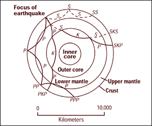
Cross section of the whole Earth, showing the complexity of paths of earthquake waves. The paths curve because the different rock types found at different depths change the speed at which the waves travel. Solid lines marked P are compressional waves; dashed lines marked S are shear waves. S waves do not travel through the core but may be converted to compressional waves (marked K) on entering the core (PKP, SKS). Waves may be reflected at the surface (PP, PPP, SS).
Seismographs detect the various types of waves. Analysis of such records reveals structures within the Earth.
Source: http://pubs.usgs.gov/gip/interior/fig2.gif ; original upload in english wikipedia, 15 April 2005 by SEWilco
Tento soubor je volné dílo, protože obsahuje materiály pocházející od United States Geological Survey (USGS), agentury Ministerstva vnitra USA. Pro bližší informaci vizte oficiální licenční pravidla USGS (anglicky).
|
Původní historie souboru
| Datum a čas | Rozměry | Uživatel | Komentář |
|---|---|---|---|
| 4. září 2005, 12:53:16 | 300 × 250 (13208 bytes) | Saperaud (diskuse · příspěvky) | Cross section of the whole [[Earth]], showing the complexity of paths of [[earthquake]] waves. The paths curve because the different rock types found at different depths change the speed at which the waves travel. Solid lines marked P are compressional wa |
Historie souboru
Kliknutím na datum a čas se zobrazí tehdejší verze souboru.
| Datum a čas | Náhled | Rozměry | Uživatel | Komentář | |
|---|---|---|---|---|---|
| současná | 6. 1. 2015, 18:54 | | 300 × 250 (13 KB) | GifTagger | Bot: Converting file to superior PNG file. (Source: Earthquake_wave_paths.gif). This GIF was problematic due to non-greyscale color table. |
Využití souboru
Tento soubor používají následující 2 stránky:
Globální využití souboru
Tento soubor využívají následující wiki:
- Využití na ary.wikipedia.org
- Využití na de.wikipedia.org
- Využití na en.wikipedia.org
- Využití na es.wikipedia.org
- Využití na fi.wikipedia.org
- Využití na fr.wikipedia.org
- Využití na it.wikipedia.org
- Využití na nds.wikipedia.org
- Využití na sk.wikipedia.org
- Využití na tr.wikipedia.org
- Využití na vi.wikipedia.org
- Využití na zh-yue.wikipedia.org
- Využití na zh.wikipedia.org